GASCOYNE PROJECT
LITHIUM POTENTIAL
- The Gascoyne Project is located to the south of a major pegmatite field within the
Gascoyne Province. The Yinnietharra lithium
project (Delta Lithium Ltd) is located 63km to the north of the Gascoyne Project. There
are many ASX listed lithium explorers
within the Gascoyne Province.
- There are pegmatite outcrops occurring on virtually all of the Gascoyne Project
tenements. These outcrops have occurrences of
common mineralogy for LCT bearing pegmatites including biotite (and white mica),
K‐feldspar, schlieren, tourmaline, muscovite
and quartz.
-
Pegmatites and granites at various sites within the project are described by GSWA:
- medium‐grained biotite‐muscovite bearing.
- pegmatite containing large flakes of muscovite and fine‐grained tonalite.
- muscovite monzogranite and a porphyritic biotite monzogranite.
- pegmatite‐banded granitoid gneiss and slightly porphyritic fine‐grained biotite
granitoid gneiss; with possible tourmaline
clusters and veins.
- tourmaline tends to be associated with the leucocratic phase granites.
- Portable XRF devices are not capable of detecting lithium directly due to X‐ray physical
limitations as lithium is too light of an
element. Indicator minerals that can be detected by pXRF device mainly include cesium,
tantalum, tin and rubidium and also many
other trace elements including potassium, calcium, strontium, yttrium, niobium, antimony,
tungsten, bismuth, arsenic, gallium,
thallium and the rare earth elements lanthanum and cerium. There are many other formulas
for targeting LCT bearing pegmatites
such as granites that have a lower potassium/rubidium ratio.


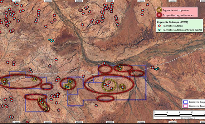
- Pegmatite outcrops have been identified at several locations within the Gascoyne Project
(GSWA) (cyan‐red dots).
- Pegmatite outcrops have been confirmed from preliminary field reconnaissance by the
Company in 2023 (yellow‐black dots).
- Pegmatite outcrop zones from GSWA and other datasets (yellow polygons) have high
potential for pegmatite outcrops and swarms.
- Further zones (red polygons) have been identified as having potential for outcropping
pegmatites based on visual interpretation of satellite imagery, surface geology,
geophysical and remote sensing imagery.
- Pegmatite outcrop zones and pegmatite prospective zones are shown from the previous image
(yellow and red polygons).
- This data will assist in field exploration programs for targeting areas that may host
fertile LCT Pegmatites with lithium mineralisation.
Gascoyne Project


